Do Something Wrong, Instead Of Nothing!

Do something wrong, rather than nothing at all. Have you ever heard that before? I have heard it from Army veteran friends, a boss, even an elder of a church.

What it means to you and me is, if action is necessary, do something, maybe ANYthing, rather than freezing in place or ignoring a problem. This is obvious when you see a tornado 5 miles away, for example; either drive away from it if you are in a car, or take shelter if you are on foot. If you have a plumbing leak in the house and no parts to replace broken pipe, then put a bucket under it, or turn off the valve, and call a plumber. All of us have seen a TV show (or maybe had it happen to us) where a bad guy or an enemy pointed a rifle and said, “Don’t move.”. What do we all say to the TV? “Don’t just stand there, run!”. Doing nothing is a much worse choice!

Man working in ditch CostaDisc2-129 - Edited
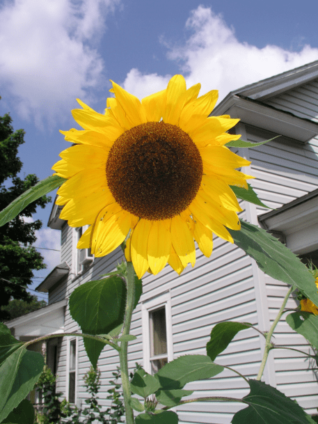
What about water rights – how does doing something wrong help? Everyone knows by now that surface water diverters need measurement devices, so put in a weir box and boards and try to measure flow if the Water Board, your watermaster, or your neighbor is promising painful consequences. Even stick boards in a ditch and seal the sides with gravel – something to take positive action to reduce future pain.

There is a philosophy based in law and a lot of experience, that says don’t put any controls on yourself until the court or government makes you. Why remodel your house to accommodate the wiring or plumbing, if you aren’t selling the house and everything works okay? Who would put a lot of money into an old truck to make it pass smog, if it just might pass a smog check the next time it has to be done? What farmer would change how he irrigates or ranches if everything still operates and the bank will keep making operating loans?

Surface water and groundwater are getting 10 times the attention they were prior to 2009. If the Water Board, or California Fish and Wildlife, or any other agency comes along, do something, anything, to comply sooner, even if it’s not the ultimate solution. Two posts ago, bureaucrats were discussed – they are still human beings and most people appreciate some effort to “get with the program”.

Be proactive, take some inexpensive action, educate yourself for free with some time in the Internet. Even a small, less-than-perfect improvement in your measurement device, flow and water use record keeping, diversion practices, or acreening, can pay back a lot more when you have to deal with agencies, a court, or an angry neighbor in the future.

Standard Units – Acre-Feet and CFS

“Mornin’ Lisa, this is Will.  Hey, my diversion dropped off last night.  You’re the next water user upstream, so I thought I’d check if you made a change last night.”

“Hey Will, how are you folks?  Yeah I did.  I was only taking 50, and my right is 112, so I bumped it up to my full right.”Aerial_Small

“112?!  How’s that work?  My farm is bigger than your place, and I only get 20!  Well Lisa, I think you’re taking too much and you better turn it down.  There’s no way you get that much!”

“Will, when we bought this place from the Sarco’s 4 years ago, they showed me in the deed where the ranch gets up to 112.  It’s right there in the deed….  Do you and Roberta have a deed or something, Will?  How ’bout me and Steve come over and talk about it.  Joe down on the bottom told me there’s been water wars here, and I don’t want hassle if we can avoid it.”Screenshot 2016-04-17 at 08.38.49


“Sure, come on over, we may end up talking to lawyers but let’s see if we can figure it out first.”

The next morning, Steve and Lisa went over and dropped in on Will and Roberta.  Lisa showed Will right in the deed where, sure enough, it said” …all water rights appurtenant to the parcel, in the amount of 112 gallons per minute…”  They also showed a Permit from the Water Board, for the same amount.

Will and Roberta laid out a copy of their 1882 filing with the county, wSenior Rightshere it showed their ranch, one of the original ranches in the decree, with a water right of 20 miners inches.
“Lisa, wait a minute, you guys divert in gallons?  How does that match up with miners inches??  Most everyone around here diverts in miners inches, not gallons.”

“When we bought the place, Joe Sarco showed us how our farm was subdivided from the original parcel.  Will, Roberta, you guys know, his farm was split into 4 equal parcels.  When he did that, and the water rights were divided up equally too.  Well, the other 3 parcels got 111, and ours got 112 gallons per minute, almost equal.”

“Well, how much is gallons per minute, in miners inches.  Steve, do you know?”

“I have no idea.  I suppose we can figure it out.  I went and look at our box, and your headgate, Will, and it looks like you are diverting several times as much as we are.”

There are all kinds of ways to measure flow and storage.  Flow rates for agricultural diversions in California include gallons per minute (gpm), miners inches, inches of head, shares, heads, and acre-feet per day (AF/day).  Take a look at the following table from http://www.jennessent.com/unit_conv/manual/no_frame/flow1.htm – there is no lack of ways to measure flow!jennessent.com_FlowMeasUnits

Some of these are very precise, and some not so precise.  “Accurate” is different than “precise”, as STEM graduates are fond of pointing out.  A measurement of 4.25 gpm is very precise, to the second decimal…but if the actual flow going down the ditch is really 9 gpm, then the reading of 4.25 gpm is nowhere near accurate.

Anyway, how much is a gallon per minute, and a miners inch?  Let’s put them in the standard units we use for agricultural diversions today.  Volumes are measured in AF, or one acre of land with water one foot deep.  Flow is measured in cubic feet per second (CFS).  Here are the relationships:

1  CFS = 40 miners inches (except sometimes it’s 50 miners inches, and there are several other variations.  Check out https://www.google.com/?ion=1&espv=2#q=dr%20hydro%20miners%20inches….)

1 CFS  =  450 gpm  =  2 AF/day

More precisely, 1 CFS = 448.84 gpm = 1.983 AF/day, but using the rounded values above is plenty precise enough for field measurements.

What about Steve’s and Lisa’s 112 gpm, and Will’s and Roberta’s 20 miners inches?  It turns out they’re both right, fortunately.  112 gpm is 0.25 cfs, close enough for horse shoes, and 20 miners inches is 0.50 cfs at the 40-miners-inches-per-cfs standard.  So, Will and Roberta do have twice as big a right as Steve and Lisa, which is easy to see once the units agree!

Why Should I Measure Flows If My Neighbors Don’t?

Why should I measure my surface water diversions if others on the same stream do not?

Unmeasured_Ditch

Installation of a device costs time and money, maybe thousands of dollars and a few days plus the use of a loader.  Sometimes the unspoken question is, if I am getting more than my water right, why should I hold myself to just diverting what is legally mine?  None of the readers of this blog would ask that, but some others out there might.

This is something like the question, why should I drive the speed limit if some or most oCHP_resizedf the other drivers are speeding?  We have all seen the answer – speeders eventually get pulled over by police or highway patrol, while those who stay close to the speed limit generally get left alone.  I’ll bet that you’re like me- I am a lot more relaxed after driving within the limits, then if I put the pedal to the metal and get somewhere an hour earlier.

50 years ago, many diversions were in the middle of nowhere and the only way there was past a protective landowner or manager.  Now roads have pushed out to the middle of nowhere and so have Google Earth, recent aerial mapping, government regulations, and government employees.

Shawn_Sticking_Weir

In the world of water diversions, the water district, ditch tender, watermaster, or Water Board folks know who is complying with the law and who is not.  The one who has a measurement device and stays within his water rights tends to get left alone.  On the other hand, the law-abiding diverter gets listened to more when he or she complains that he’s not getting the water he should.winning-trophy

Social influence – peer pressure – also come into play after the first person on a stream installs and starts using a measurement device.  The fact that a neighbor invested and did the right thing to comply with water laws encourages other diverters to do the same.  Or at least, the water right holders who don’t have a weir or meter can see that it is inevitable and they’ll be more readily convinced to do the same.

Sometimes a diverter is not getting thesunflower full water right, even though he thinks he is.  In this case, being able to measure the water means being able to demonstrate that when the diversion is increased, it is still within the legal amount. I have seen this happen a few times, and the result is a rancher or farmer who is a whole lot happier than he or she was last week!

Summary of Water Rights, Flow Measurement Posts So Far

There have been 25 posts so far, on the types of California surface water rights, flow measurement devices, and how to measure diverted flows.  You’ll see new posts once or twice a week.  Please send suggestions for post topics!  We have discussed:

  1. All Water Rights, California
  2. Read Me My Rights (How do you know if you have a water right?)
  3. Reasonable And Beneficial Use Depends On Who You Are
  4. The Smartest Water Expert In California (Chuck Rich)
  5. Riparian Rules by Chuck Rich
  6. Water Rights – Why Do They Exist? Which Kinds Are There?
  7. Water Rights And Engineers
  8. California Water Right Holders Now Required To Have Measuring Device
  9. What Is Your Place Of Use?  (Where can you legally use your right?)
  10. Places Of Use – Adjudicated (Decreed) In The State Superior Court
  11. A Place For Permits And Licenses (Places of Use)
  12. Nothing Secret About It  (This is all public information.)
  13. Quick Change of Subjects: What’s a Water Right Permit Cost?
  14. Life Of Reilly: If You Can’t Measure It, You Can’t Manage It!
  15. How to Divide Up a Decreed Water Right – Part 1
  16. How to Divide Up a Decreed Water Right – Part 2
  17. Weirs – Planning, Building, Measuring Flows
  18. From weir to orifice in only an hour
  19. Chilean Water Rights at (darn near) the Driest Place on Earth
  20. Some Hope in Rain and Snow Totals
  21. Is John Stealing Water?? Orifices – Right Size and How to Measure
  22. Worried about SB 88? That’s what this blog is for! Get a device in, send a photo to the Board, record and report your diversions
  23. Flumes – installing for decades of flow measurement, Part 1
  24. Simple Weirs and Orifices, on video, and in photos!
  25. Diverters must report weekly, daily, or HOURLY starting 2017!

Is John Stealing Water?? Orifices – Right Size and How to Measure

Is John Stealing Water??  John Casey has a cattle ranch near Adin, where he grows pasture and hay to raise about 70 Angus steers.  His place is 240 acres with lower irrigated land and forest on the higher part.  He has an adjudicated water right of 2.00 cubic feet per second (cfs) from Preacher Creek, to irrigate 80 acres.

John’s downstream neighbors claim he steals water.  He says he can show that he takes only 2 cfs, or less when the flow drops down in the summer.  Can he prove it?John_Headgate_edit

As we can see, he has a square headgate at the head of his ditch.  It is 2.0′ wide, and can open up to 1.5′ high.  Right now, John says he is diverting 1.05 cfs.  His evidence is that his gate is open 0.15′, the water is 0.57′ deep on the upstream side, and the water is 0.20′ deep on the downstream side.  Is that enough to check what he says?

The box in which the gate sits has smooth walls, and the gate closes flush with the bottom when John is not diverting.  The water continues in a straight path from upstream to downstream.  That means the weir has “suppressed” sides.

This is in contrast with, for example, a hole cut in the middle of a 2″ x 12″ weir board.  The water on the sides has to make the turn to go straight through, so the hole in the board is an example of a “contracted” orifice.

Let’s look at the tables for orifices in the back of the Water Measurement Manual.  Table A9-3 is for submerged, suppressed weirs.WMM_Table_A9-3_suppressed

We can’t see the downstream side of the weir, but the water is above the bottom of the edge of the gate, so it is submerged rather than free-flowing.

This table has flows calculated for a minimum area of 2.0 square feet (sq. ft.).  However, the area of the opening at John’s headgate is 2.0′ wide x 0.15′ high, or 0.30 sq. ft.  Fortunately, the equation, Q=0.70A(2g Δh)^0.5, is listed right at the top of the table.  We can calculate the flow using that.  Q is the flow in cfs, A is the area of the orifice hole, g = the acceleration due to gravity, or 32.2 ft/second^2 (feet per second squared), and Δh is the difference between the upstream and downstream water depth.

So the flow Q = 0.70 x (2.0′ x 0.30′) x (2 x 32.2 x 0.37′)^0.5 = 1.03 cfs.  So far so good – John is taking 52%, or just over half of his right when 100 percent of flows are available.  But, how much flow is actually available right now?

Let’s use the “sum of the boxes” method.  Instead of measuring the amount of water in Preacher Creek at the top, before any diversions, and then estimating how much flow is being lost to evaporation, transpiration, and infiltration, and then estimating how much flow is subsurface above John Casey’s ranch and “pops up” out of the ground below, we’ll look at what each diversion amount is, plus the amount still in the creek after the last diversion.  This is very useful because none of the instream losses have to be estimated – we just add the diversions and flow still in the creek, and that amount IS the available supply.  Some Superior Court judges in past decades were pretty smart and actually ordered that available flows be calculated this way.

Susan_1_of_2_DecreeParaAvailWaterEqualsDiversionsSusan_2_of_2_DecreeParaAvailWaterEqualsDiversionsThe paragraph above, from the Susan River Decree, defines available water supply as what is being diverted, plus the flow passing the last diversion.

There are 4 diversions on Preacher Creek, and here are the amounts being diverted:

  • Diversion 1 (John Casey) 1.03 cfs  of a 1.60 cfs water right, 52% of his total right
  • Diversion 2 (Amy Hoss) 1.67 cfs  of a 3.80 cfs water right, 44% of her total right
  • Diversion 3 (Mark and Cindy Sample) 0.55 cfs  of a 0.88 cfs water right, 62% of their total right
  • Diversion 4 (Quint and Marcie Minks) 1.32 cfs  of a 2.50 cfs water right, 53% of his total right
  • Flow still in the creek past the Minks Diverison – Quint estimates about 0.7 cfs

The total diversion-plus-bypass flow is about 5.3 cfs.  The total rights on the creek are 9.48 cfs.  Therefore, the total available flow = 5.3 / 9.48 = 56%.

So, John is right, he is not stealing water!  He is taking 52% of his water right, when he could be taking 56% according to the “sum of the boxes” method.  Not only that, but Amy could take more, the Samples should reduce their diversion, and the Minks’s could take a tad more.  Well, that’s theoretical – Quint and Marcie Minks probably cannot seal up their dam completely, so there may be a little bit less flow actually available for diversion.

How to Divide Up a Decreed Water Right – Part 2

This post is an old version and has been updated here: https://wordpress.com/post/allwaterrights.com/4949

…continued from yesterday’s Part 1….  To recap, in 2005, San Bernardinoans Arnold and Eileen Williamson bought property near South Cow Creek up in Northern California to retire on and build a new house.  They were set on drilling a new well and uncertainties in how much they could pump got them looking into their surface water right – do they have one for sure, and how much water is it?  They ended up taking their questions to an engineer who could answer their questions.  The map below is one of several from the report they got from the engineer, showing their property boundary on the 1965 decree map of irrigated lands:Ex_2_Williamson_Parcel_Outline_on_DecreeMap_reduced

The report cost $350.  They’re pretty sure they would have paid a lot more than that to see an attorney.  The engineer warns them that if it gets contentious and they can’t work out access to the water with their neighbors, they may end up having to get legal help.  He recommends Jeff Swanson if it comes to that – he’s an expert water rights laywer in Redding.  For now, though, they have documentation they can discuss with their neighbors to work on getting their water right to their property.

Their property is on land that back in 1968 belonged to Howard and Gladys Leggett.  It has an adjudicated second priority water right for irrigation equal to 0.063 cubic feet per second, or 28.5 gallons per minute, 24 hours a day, 7 days a week, from March through October.   This 2nd priority right is less than the second and third priorities on the upper creek and tributaries, but it is the highest irrigation priority on the lower creek.  Back when the property was flooded, that was usually enough to flood irrigate their entire lot to grow pasture or hay.  That’s great news!

As natural flows drop during the summer that amount is reduced and everyone with a lower creek second priority has to reduce their diversion by the same percentage.  In normal and wet years they could keep their pasture, hay, or whatever else they plant, irrigated for most or all of the irrigation season.  And whether or not they use the water, the right does stay with the land and protect their property value.

What else was in their report?  There was a cover letter, and next some excerpts from the decree.  Schedule 1 lists the places of use for all the original owners.  The Leggetts’ description takes up most of page 60; the Williamson’s property is on the 69.8 acres listed in the second paragraph for the Leggett land:

SCow_Sched1_Leggett_Places_Of_Use


Schedule 2 lists all the points of diversion, whether gravity diversions or pumps.  The Leggett property actually could get water from two diversions, a pump from the creek, and a proposed second, movable diversion on the creek.  That’s convenient – per the decree they could already divert their water from someone else’s existing diversion, or pump their water from Diversion 95, or they could get it from anywhere they can get agreement from the landowner!SCow_Sched2_Leggett_Points_Of_Diversion

SCow_Sched2_Leggett_Points_Of_Diversion_2

Schedule 6 lists the water rights for Lower Cow Creek – other schedules have rights for the upper creek and tributaries.  This is interesting: there are four priorities of rights and

SCow_Sched6_LowerSCC_Leggett_Allots_second_page

this part of the Leggetts’ property has a 1st and a 2nd priority right.  What does that mean exactly?  The decree explains that 1st priority rights are domestic – houses and gardens.  It’s a very small right and it is not clear whether or how it should be divided up among the all the subdivided parcels that used to be the Leggett ranch.  The engineer noted it in the cover letter.

How was the water right calculated for the Williamsons?  Using a geographic information system, or GIS, the engineer used his training and years of experience to precisely overlay the Assessor Parcel Map on the decree map.  Then he measured the acreage for both, and prorated the water right by area.  The following screenshots of the Excel spreadsheet shows these calculations.

TractMgmtSheet_20151222_Arial_12_01_reduced

TractMgmtSheet_20151222_Arial_12_02_reduced

TractMgmtSheet_20151222_Arial_12_03_reduced

Time to fess up: this was a water right subdivision of a made up parcel of land, and the Williamsons don’t actually own it.  However, this story is one that happens every day, when a landowner asks “How much is my water right, really?”  Having information before arguing with neighbors, seeing attorneys, sending legal letters, and going to court, can help smart people who generally have good relationships work out happy and agreeable solutions.  The Williamsons were smart and talked politely with their neighbors, the Turings and Poulens and Winters’s.  Now they have a good basis to live peacefully in their neighborhood for many years, and Arnold can borrow Charlie’s lawnmower until he gets his own.

Ex_2_Williamson_Parcel_Outline_on_Aerial_reduced

How to Divide Up a Decreed Water Right – Part 1

This post is an old version and has been updated here: https://wordpress.com/post/allwaterrights.com/4949

Back in 2005, Arnold and Eileen Williamson bought property near South Cow Creek in Shasta County.  They live in San Bernardino and plan to retire early, and build a new house on their land.  The parcel is part of an old ranch just off Highway 44.

The Williamsons paid $220,000 for the 3.55 acre lot.  That seemed high compared to similar parcels in the area, but they were assured the land has adjudicated water rights from South Cow Creek.

Arnold and Eileen brought their travel trailer to live on the land while they are building a new house.  Their savings account is in good shape so they are going to build a nice 2,200 square foot, single story ranch house with a garage and a shop.  They talked to a well driller 10 years ago and he assured them it would be easy to put in a well, for a cost of around $18,000.Williamson_Overview

When Arnold and Eileen went to get a permit to drill a well, they ran into unexpected problems.  Parcels on either side have their septic systems close to the common property lines, so their possible well locations are few.  Maybe a bigger issue is the passage of the Sustainable Groundwater Management Act in 2014.  Will their pumping rate be limited, and will their well-drilling permit application get held up?

Now the Williamsons are checking into their surface water right.  Is it enough for some pasture for horses and a few cows, in addition to the house and garden?  The Turings who live on the east side say there are no water rights.  The Poulans, to the west, say they have lived here for 6 years and they have never had water – they think the water right was bought off the place, or lost because of non-use.Williamsons_and_neighborsNow the Williamsons are upset and headed toward just plain mad.  The real estate agent said they had rights, and didn’t the title companies insure it??  After a few frantic calls, they found out that title companies don’t insure water rights.  But, their realtor gave them the number of some folks over on the north side of the highway, and they have a “decree map”.  Arnold and Eileen head over to the Winters’ place to look over the maps.  Brad and Jenny Winters even have the Internet address where the decree can be downloaded:  http://www.waterboards.ca.gov/waterrights/board_decisions/adopted_orders/judgments/docs/cowcreek_jd.pdfSCow_Sheet_5_screenshot

It turns out that the Cow Creek adjudication does not have maps, but an engineering report done a few years before the decree was issued does have the maps.  Brad and Jenny have that report, too, so they have Sheets 1 through 5 showing the “Diversions And Irrigated Lands” on Cow Creek.  Sheet 5 covers the area including the Winters and Williamson places.  Sheet 5 has a lot of “irrigated lands”Leggett_Focus_Area according to the legend – the green areas.

By looking at the maps, and their Assessor Parcel Map they have in their escrow package, it sure looks like their property is completely within the green area.  Great!  Now, how do they figure out if they actually have a water right?
AP_Map_59-98_croppedAfter asking around, Arnold and Eileen figure out they will need to see an attorney.  They call around and find out there are a couple of engineering companies that can see them faster, and they might cost less.  An appointment with Rights To Water EngineeringEx_2_Williamson_Parcel_Outline_on_DecreeMap_reduced   the next morning is their next step.  Within a couple of days, they have a nice report in their hands and answers to their questions.  So what did they find out?  That is an answer for the next post.

For now, good night to all….


Life Of Reilly: If You Can’t Measure It, You Can’t Manage It!

A friend of mine, Chris Reilly, summarizes everything you need to know about measuring flows into your surface water diversion:  “If you can’t measure it, you can’t manage it!”  Except for riparian rights and some very small water rights, diverted flows have to be measured.  Why?

Full_DitchFlooded_Field

Dry_DitchLegally, to ensure your neighbors, the Board, and/or a Superior Court Judge that you are diverting no more than your water right.  Practically, how do you know if you are getting as much water as you should?  As surface flows decrease through the summer, every bit less means some pasture, hay, orchards, row crops, or something else does not get irrigated.

If you have nWMM_Cover_smallever measured flow into a ditch before, well, here goes, I am going to leak the secrets right here, I’m going to violate the Unspeakable Code Of The Water Measuring Brotherhood, the ve
ry deepest, most powerful wisdom of how to measure your flow will appear on this very page.  After this, who knows if you will ever hear from me again, once this classified information is made public?  Well, not really, but few people have heard of the Bible Of Water Measurement, the
 USBR Water Measurement Manual (WMM)

Let’s look at 3 common measurement devices detailed in the manual:  weirs, orifices, and flumes.  Properly installed and maintained, these devices can measure flow within plus or minus 5% of the actual amount.  The photos below are from the WMM, which has lots of diagrams that make it easy to see the details of how each device works.  First, the weir:

WMM_weir

You have seen these before, they’re just a level plate or board of a specific width, with a relatively still pool behind them.  That’s it!  By measuring the height of the pool above the edge of the plate or board, you can use tables or equations from the WMM to determine what the flow is.

WMM_orifice

Above is shown an orifice.  Not much to see, is there?  In this case, it is just a hole, lower than the upstream flow.  That is physically all an orifice is.  Knowing the size of the hole, and how high the water is over the center of the hole, and how high the water is down the ditch, a table or equation can be used to figure out the flow.  The gentleman above is using a square gate with a certain width.  The area changes with how high the bottom of the gate is, not hard to figure out.

WMM_Flume_01

The photo above shows a Parshall Flume.  These are great for measuring high flows without needing a lot of “head” or the drop in the water from upstream to downstream.  By knowing the depth at a certain point, a table or equation can give the flow amount.

We’ll go into how to use tables for specific measurement devices in later posts.  It’s enough for now to know that if you have a decent measurement device, then you CAN manage your flow, as well as proving that you are taking no more than your legal water right.

Read Me My Rights

How do you know if you have a water right? Right up front, you know I am not a water rights attorney, and you may end up needing to consult one. There are some good ones. Make sure you go to an attorney who is…a water rights attorney, not an insurance attorney, or a workers comp attorney….house 20100222EAV2232

If you live in a town, city, county water district, or a number of other areas that provide water hookups or delivery by ditch, then you are relying on the provider’s water right. That may be any of the kinds of rights mentioned previously: riparian, rancho, pueblo, appropriative pre-1914, appropriative post-1914, groundwater, adjudicated, prescriptive (proven and adjudicated), or contract.

What if you own a place outside of town, and you have always relied on a well?
Might you have a surface water right? If you are on or near a stream, the answer is a definite “maybe”. Hopefully when you bought the place, the previous owner told you if the place has a decreed (adjudicated) right, or appropriative right, or some other water right.

If you never knew and wanted to find out, then the first thing to do is ask your neighbors. IMPORTANT: maintain good relationships with the peWilliamsons_and_neighbors
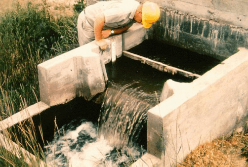
ople who live around you if at all possible. You never know when you need someone’s help, or want to borrow a tractor, or need to peaceably resolve a thorny issue…or get their likely-very-good idea of whether you have a water right, and how much it might be. A neighbor’s opinion is not proof, but someone who has lived in the area for 40, 50, 60 years probably has a good idea.

If your neighbors don’t know (or the relationship isn’t real friendly), the one-stop-shop for most water rights is the State Water Resources Control Board in Sacramento, or 59-98the “Board”. Get your County Assessor Parcel Number (APN), which is in your purchase documents, or probably can be found online by now in every California county. Call the Board at (916) 341-5300, tell the person what you need, and when you are forwarded to the person in the know, give him or her your APN. Write down everything you are told.

Hopefully you get to talk to a knowledgeable person who can tell you “yes” and what type of right. The Board tracks appropriative water rights: all post-1914 rights, and some pre-1914 rights. The Board posts most of the important court adjudications on their web site, so the person can probably tell you if you are in an area with decreed rights.

If the answer you get from the Board doesn’t seem right, you mMan working in ditch CostaDisc2-129 - Editedight call again and get a second opinion. If it still sounds funny, and you have asked your (friendly) neighbor, and checked your property deed for indications, then your best option is probably to consult a water rights attorney.

If you live on a stream or lake, or have a spring on your property, you most likely have a riparian right. Caution here – it’s not guaranteed. Your property has to touch, cross, or include the water body. Then, you have to check your deed on the very small chance the right was transferred to some other parcel. You may live one parcel away from a stream, and there is a very small chance your property has rights reserved, as evidenced by your deed, from when the original owner split off your property. Not likely.

South_Cow_Sht5_Hall_smallIf you live on an adjudicated stream, or at least your property is one of those in a decree on part of a stream, then the court has told you in writing how much water you can take, in what season. Typically these decrees cover the irrigation season, and some also define winter rights. If this is your case, your right is limited to what the court said.

If you ask the Board about your riparian right, the answer you get can vary from, “I don’t think you have any rights” to “You very likely have a right to what you can reasonably and beneficially use.” The person on the phone cannot be certain your property actually touches a water body.

In summary, it’s easy, right? Well, no it’s not. With this information, you have a process you can use to figure it out. Happy hunting!

All Water Rights, California

Welcome to the All Water Rights Blog!